

 Português
  English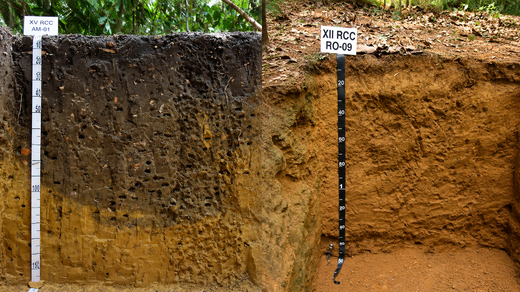
Global study finds soil data concentrated in agricultural areas and temperate forests and warns of declining field surveys
Soil profiles worldwide are essential records for understanding how soils form, how they are distributed across landscapes, and how they respond to climate change and different land uses. However, this information remains highly uneven across regions, biomes, and land-cover types.
Published in the European Journal of Soil Science, the article “Soil Diversity and Climate: An Overview of Profile Data and Acquisition With the WoSIS Global Legacy Dataset” analysed the 2023 WoSIS global database. To do so, the researchers integrated soil records with Copernicus land-cover data and the delineation of the world’s major terrestrial biomes. The study brings together researchers from several countries and includes Professor Grace B. Alves, a member of the COLAPSO Research Group, among its co-authors.
How soil profiles are distributed worldwide
The analysis considered 228,090 records, of which 173,100 corresponded to full soil profiles and 54,990 only to topsoil data. Among the different land-cover classes, croplands account for 29.5% of the available profiles. Herbaceous vegetation comes next, representing 17.7%.
By contrast, environments such as mangroves, wetlands, tundra, and several arid and forest systems remain underrepresented. Consequently, this uneven distribution limits knowledge of soil-forming processes and soil functions in different ecosystems.
In addition, temperate broadleaf and mixed forests account for 32.4% of the records. Tropical, arid, and cold biomes, however, have considerably lower densities of documented profiles. As a result, much of the world’s soil diversity is still not adequately represented in global databases.
The distribution of soil profiles worldwide reflects both the planet’s environmental diversity and the historical priorities of soil surveys. Therefore, regions that have been studied more intensively tend to accumulate more detailed information, while remote or difficult-to-access environments remain poorly documented.
Field surveys declined after 1990
Another important result concerns the temporal evolution of soil surveys. The number of profiles with recorded sampling dates increased significantly from the mid-twentieth century to the 1980s. However, this number declined after 1990.
According to the authors, one possible explanation is the growing emphasis on digital soil mapping, modelling, and remote sensing. As a result, direct soil description in the field may have lost ground in some areas of research.
Nevertheless, this interpretation does not imply opposition between traditional methods and digital technologies. On the contrary, maps, models, and digital systems depend on reliable field data for their development, calibration, and validation.
Why soil profiles are still lacking worldwide
Soil profile description remains essential for identifying horizons, understanding pedogenic processes, interpreting soil functions, and assessing land-use limitations. Therefore, advances in digital soil science do not eliminate the need for direct observation.
In this sense, the authors call for the recovery, standardisation, and publication of legacy soil surveys. Whenever possible, these records should include profile locations, horizon descriptions, photographs, and physical and chemical analyses.
In addition, the article highlights the need to train a new generation of pedologists capable of integrating fieldwork, soil classification, databases, and digital tools. This integration can improve both scientific knowledge and strategies for soil conservation and management.
Expanding and improving data on soil profiles worldwide can also contribute to more reliable maps, more robust environmental models, and more effective soil-protection policies.
Amazon soil profiles illustrate tropical soil diversity
The Brazilian contribution also appears in photographs of two soil profiles from the Amazon. One is a Ferralsol, corresponding broadly to Latossolos in the Brazilian Soil Classification System. The other is an Anthrosol associated with Amazonian Dark Earths. The photographs were taken by Grace B. Alves.
Read the article
SCHILLACI, Calogero et al. Soil Diversity and Climate: An Overview of Profile Data and Acquisition With the WoSIS Global Legacy Dataset. European Journal of Soil Science, v. 77, e70372, 2026.
https://doi.org/10.1111/ejss.70372
Further reading
This study is connected to other posts on the COLAPSO Research Group blog about the importance of soil profiles and the relationships between soils and landscapes. To explore the topic further, we recommend:
Soil profile: a window into the genesis, degradation, and memory of landscapes, which discusses how horizon description helps interpret soil formation, degradation processes, and landscape history.
Soil and Landscape: what are we still trying to understand?, which presents questions and research directions for an integrated analysis of soils, relief, and landscape evolution.