


 Português
 English
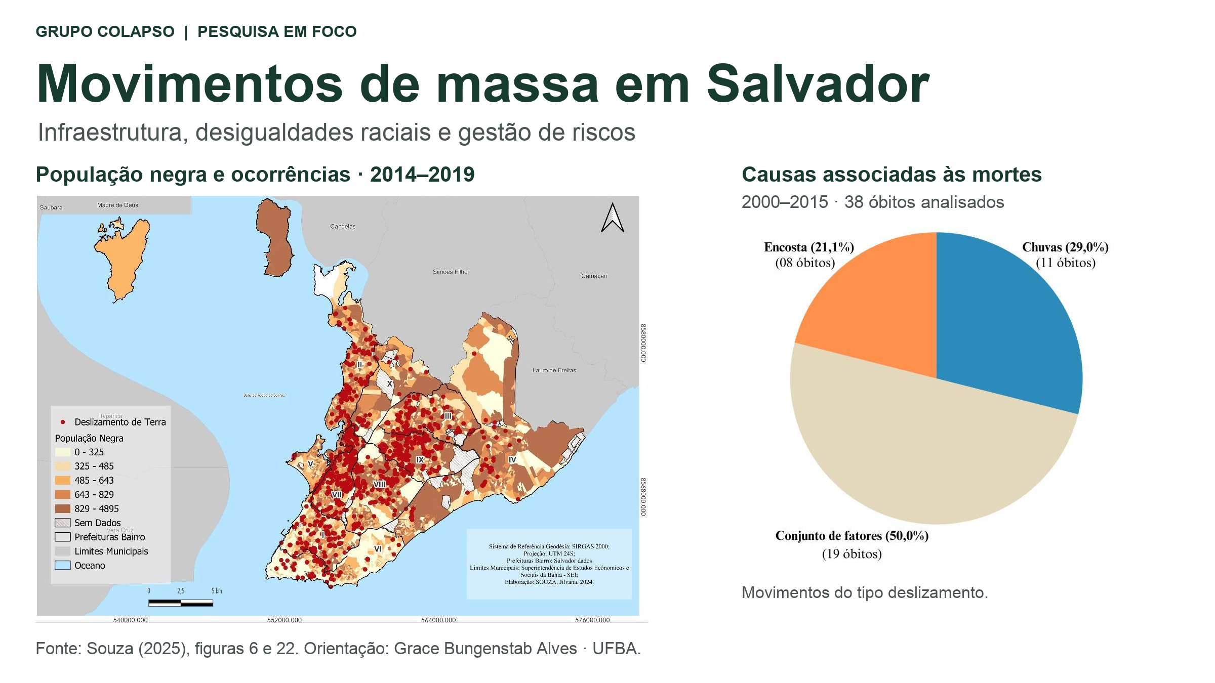
Research by the COLAPSO group links mass movements, infrastructure, and racial inequalities in Salvador, revealing the limits of risk management focused on emergency response.
During Salvador’s rainy season, plastic sheeting stretched across hillsides is a familiar sight. Used as a temporary protective measure, these tarps also raise a question: what remains unresolved when an emergency covering becomes a lasting feature of the landscape? Understanding disasters in the city requires examining both the water entering the ground and the housing conditions, drainage systems, and public decisions that precede each event.
This approach appears in a series of studies by Jilvana Ferreira da Silva Souza, supervised by Grace Bungenstab Alves, at the Federal University of Bahia (UFBA) within the COLAPSO research group. The research spans slope susceptibility, structural racism, and risk management, culminating in Souza’s 2025 master’s dissertation, Por trás da lona preta: necropolítica e deslizamentos em Salvador, Bahia, and several conference publications.
An initial analysis of institutional documents was published in 2023 under the same main title, Por trás da lona preta. In 2024, the presentation “Cidade de papel: relação entre precipitação e deslizamentos em Salvador, Bahia (Brasil)” presented findings on rainfall and fatal events at the International Seminar on Multirisk.
Terrain helps explain the process; the city helps explain the risk
Mass movements involve the downslope displacement of soil, rock, or other materials under gravity. The studies discussed here focus on landslides, a particular type of mass movement. Their occurrence depends on factors such as rock and soil properties, terrain characteristics, and water movement. Slope excavation, leaking pipes, and drainage changes can also compromise stability.
A study by Jilvana Ferreira da Silva Souza, Laís Fagundes Jesus Silva and Grace Bungenstab Alves, presented at the Brazilian Symposium on Applied Physical Geography in 2019, identified relationships between landslide occurrences, geological faults and boundaries between different rock types. The findings support an integrated approach to landscape analysis: slope steepness alone does not explain where events occur.
Susceptibility and risk, however, describe different aspects of the problem. Susceptibility concerns a terrain’s propensity for particular processes. Understanding risk and potential losses also requires considering the exposed people and buildings, their protection, and their capacity to cope with and recover from impacts.
Research presented in Athens in 2019, involving Grace Bungenstab Alves and other team members, illustrated this distinction. Areas with high environmental susceptibility could have different levels of social vulnerability. In that analysis, these factors combined to increase risk in Salvador’s northwestern part compared with the southeast.
What fatality records reveal
In her 2025 dissertation, Souza examined records of mass movements and building collapses involving casualties between 2000 and 2015, alongside urban planning documents, public reports and rainfall data. The study assessed the two event types separately: a building collapse does not necessarily involve a mass movement on a slope.
For the 38 deaths associated with landslides examined in the study, the final classification divided fatalities into three groups:
- 19 deaths in events associated with a combination of factors, including rainfall, soil saturation and infrastructure deficiencies;
- 8 deaths in events associated with slope stabilization problems or interventions on hillsides;
- 11 deaths in rainfall-related events.
Approximately 71% of the deaths in this dataset therefore fell into the first two groups. This percentage refers to the fatalities examined, not the proportion of all mass movements in Salvador or each factor’s physical contribution.
The classification also required comparing documents. Civil Defense records listed two mass movements in 2015 as associated with heavy rainfall. However, the report from Operação Chuva, the city’s rainy-season emergency program, described a combination of rainfall, poor construction conditions, and problems with water supply, sewerage, or drainage. The researcher therefore placed these events in the combined-factors category.
Rainfall remains a potential trigger. The findings show that treating it as the sole explanation for a disaster obscures conditions that could have been addressed before the emergency.
Inequality is also part of the landscape
Souza’s 2021 undergraduate thesis and her master’s dissertation extended the investigation to Salvador’s historical development and unequal access to land, housing and urban services.
The researchers interpret the exposure of Black and low-income populations to disasters in relation to segregation and the unequal distribution of infrastructure and protection. In this approach, environmental racism concerns how risks and losses fall disproportionately on different social groups.
The dissertation also draws on the concept of necropolitics to interpret state decisions and omissions that leave certain populations exposed to the possibility of death. This theoretical interpretation is grounded in historical, spatial, and documentary analysis, highlighting the political conditions through which risk is produced and maintained.
From emergency response to sustained prevention
The investigation went beyond event records. Souza examined 347 entries in the City Council’s official gazette from 2011 to 2021, municipal plans and an administrative inquiry by the Public Prosecutor’s Office concerning Salvador’s hillsides.
The findings point to a gap between planning instruments and implementation. While the studies acknowledge institutional changes, they identify a predominance of emergency responses and isolated interventions over integrated, long-term policies during the periods examined.
This issue is explored in Operação Chuva em Salvador: quanto vale ou é por gota?, by Jilvana Souza, Grace Bungenstab Alves and Paulo César Zangalli Júnior, which examined program reports from 2015 to 2021. It also appears in Entre acidentes e desastres: um olhar sobre a gestão de riscos and Um olhar sobre os documentos institucionais: gestão de riscos em Salvador, Bahia, both published by Souza and Alves in 2025.
For the authors, the language used to describe these events also matters. Describing recurring events as accidents can obscure known vulnerability conditions. Prevention requires linking slope knowledge to drainage, sanitation, technical assistance, building maintenance, and access to safe housing.
What the findings can—and cannot—tell us
The fatality data examined cover 2000 to 2015. They cannot, on their own, establish subsequent trends in deaths or assess the effectiveness of later municipal measures. The rainfall records also have an important spatial limitation: they come from the Ondina weather station and do not necessarily represent rainfall at every hillside location.
The studies should therefore not be read as predictions of mass movements in specific neighborhoods or as evidence that rainfall no longer matters. Their contribution is to show that reducing losses requires understanding physical processes, social inequalities and public decisions together.
This perspective connects with other COLAPSO research. In Understanding Risk to Improve Planning, the group combines data with community experiences to examine climate impacts. Its research on urban heat islands in Salvador also helps explain how environmental conditions vary within the city. Both linked posts are in Portuguese.
A question runs through this work: how can knowledge become protection? On Salvador’s hillsides, that means making prevention a sustained public commitment, addressing the conditions that turn rainfall into a threat to life.
References
ALVES, Grace Bungenstab; SOUZA, Jilvana; SILVA, Laís; SANTANA, Jessica; ZANGALLI JUNIOR, Paulo. Risks of landslides in Salvador, Bahia (Brazil): the relationship between the environmental susceptibility and social vulnerability. In: REGIONAL CONFERENCE ON GEOMORPHOLOGY, 2019, Athens. Abstract book: geomorphology of climatically and tectonically sensitive areas. Athens: Organizing Committee of the Regional Conference on Geomorphology, 2019. p. 130. Available at: official abstract book. Accessed: 28 Oct. 2026.
SOUZA, Jilvana Ferreira da Silva. Riscos socioambientais, racismo estrutural e deslizamentos em Salvador. 2021. Undergraduate thesis (Bachelor’s degree in Geography) – Institute of Geosciences, Federal University of Bahia, Salvador, 2021. Supervisor: Grace Bungenstab Alves. Available at: UFBA Institutional Repository. Accessed: 28 Oct. 2026.
SOUZA, Jilvana Ferreira da Silva. Por trás da lona preta: necropolítica e deslizamentos em Salvador, Bahia. 2025. Master’s dissertation (Geography) – Institute of Geosciences, Federal University of Bahia, Salvador, 2025. Supervisor: Grace Bungenstab Alves. Available at: UFBA Institutional Repository. Accessed: 28 Oct. 2026.
SOUZA, Jilvana Ferreira da Silva; ALVES, Grace Bungenstab. Por trás da lona preta: necropolítica e deslizamentos em Salvador, Bahia. In: ENCONTRO NACIONAL DE PÓS-GRADUAÇÃO E PESQUISA EM GEOGRAFIA, 15., 2023, Palmas. Anais […]. Campina Grande: Realize Editora, 2023. Available at: XV ENANPEGE proceedings. Accessed: 28 Oct. 2026.
SOUZA, Jilvana Ferreira da Silva; ALVES, Grace Bungenstab. Cidade de papel: relação entre precipitação e deslizamentos em Salvador, Bahia (Brasil). 2024. 11 slides. Presentation at the International Seminar on Multirisk, 2024. DOI: 10.13140/RG.2.2.15684.44167. Available at: ResearchGate. Accessed: 28 Oct. 2026.
SOUZA, Jilvana Ferreira da Silva; ALVES, Grace Bungenstab. Entre acidentes e desastres: um olhar sobre a gestão de riscos. In: ENCONTRO NACIONAL DE PÓS-GRADUAÇÃO E PESQUISA EM GEOGRAFIA, 16., 2025, Macapá. Anais […]. Campina Grande: Realize Editora, 2025a. Available at: XVI ENANPEGE proceedings. Accessed: 28 Oct. 2026.
SOUZA, Jilvana Ferreira da Silva; ALVES, Grace Bungenstab. Um olhar sobre os documentos institucionais: gestão de riscos em Salvador, Bahia. In: SIMPÓSIO BRASILEIRO DE CLIMATOLOGIA GEOGRÁFICA, 16., 2025, Crato. Anais […]. Crato: Even3, 2025b. p. 2935–2945. Available at: XVI SBCG proceedings. Accessed: 28 Oct. 2026.
SOUZA, Jilvana Ferreira da Silva; ALVES, Grace Bungenstab; ZANGALLI JÚNIOR, Paulo César. Operação Chuva em Salvador: quanto vale ou é por gota? In: CONGRESSO BRASILEIRO DE GEÓGRAFAS E GEÓGRAFOS, 8., 2024, São Paulo. Anais […]. São Paulo: Associação dos Geógrafos Brasileiros, 2024. Available at: VIII CBG proceedings. Accessed: 28 Oct. 2026.
SOUZA, Jilvana Ferreira da Silva; SILVA, Laís Fagundes Jesus; ALVES, Grace Bungenstab. Susceptibilidade a deslizamentos em Salvador-BA. In: SIMPÓSIO BRASILEIRO DE GEOGRAFIA FÍSICA APLICADA, 18., 2019, Fortaleza. Anais […]. Fortaleza: [s. n.], 2019. Available at: ResearchGate. Accessed: 28 Oct. 2026.
12:56