In Brazil’s Northeast semiarid region—shaped by drought, strong seasonality, and often shallow soils—why do we still find Latossolos, which are deep, highly weathered profiles typically associated with wetter tropical conditions?
There isn’t a single, neat answer. Making sense of this apparent contradiction requires treating the landscape as an evolving system in which soil and relief must be interpreted together, across multiple spatial and temporal scales. In other words, landscapes have memory, and soils are a central part of that memory.
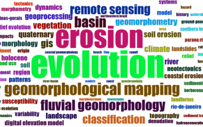
This post highlights the main ideas from Grace Bungenstab Alves (2025), who shows how integrating soil and relief helps distinguish older legacies from more recent reorganizations in the Northeast semiarid region, and why this matters for understanding vegetation patterns, water pathways, and the processes that reshape relief.
“In the semiarid region, soil is not only a ‘product of today’s conditions’; it preserves the memory of the processes that built this landscape.”
Why do separate inventories not explain landscape evolution?
Listing soil types, mapping landforms, and describing vegetation are all essential. The problem starts when an inventory is mistaken for an explanation. Treating soil and relief as separate layers does not explain processes or landscape evolution.
When soil and relief are analyzed as independent “strata,” we lose what actually organizes the landscape: the processes that connect materials, forms, and time. That is why quick regional narratives often fail in the most complex settings, especially transition zones.
Soils record inherited conditions, but they also reorganize actively, altering landforms and influencing which vegetation communities can persist. In this context, the “contradiction” of Latosols in a semiarid environment ceases to be a puzzle and becomes an interpretive key.
Two broad soil sets to interpret the Northeast semiarid region
As a synthesis, the article proposes two broad soil sets, grouped by the evolutionary history of the landscapes where they occur:
-
Relict soils (lateritic): inherited from past, wetter tropical conditions and associated with surfaces and materials that preserve part of this “deep-time” history.
-
Recent soils (formed under semiarid conditions): including Luvissolos, Planossolos, Vertissolos, and Chernossolos, whose distribution is linked mainly to more dissected landscapes shaped by Cenozoic denudation.
This framework helps organize regional interpretation without turning the landscape into a simple rule. It invites more precise questions: What is inherited? What reflects the recent adjustment? And what lies “in between,” in transition?
Figure 1 – Soil groups of Northeast Brazil classified by formation conditions, profile depth, or drainage. Source: Alves, 2025.
Vertisols with Holocene OSL ages: why does this call for caution?
A common pitfall in rushed interpretations is to read an age measured in soil as if it automatically represented the age of deposition.
In the article, Vertisols from the Northern Sertaneja Surface yield Holocene ages from Optically Stimulated Luminescence (OSL). The key point here is methodological and straightforward: in settings with active pedogenesis and vertical mixing, the chronological signal may reflect internal soil processes—reorganization and pedogenic dynamics—rather than simple, recent deposition of the parent material.
The takeaway is clear: soil ages should not be treated as an automatic stamp of “recent morphogenesis.” Interpreting what an age actually means requires combining absolute chronology with detailed soil description, micromorphological evidence, and geomorphological reading.
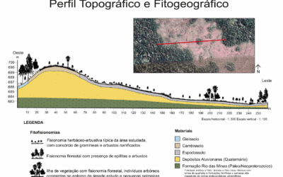
Figure 5 – Vertisol landscape in Sousa (Paraíba, Brazil): (a) location map; (b) soil profile details; (c) profile sketch with ages; (d) grain-size and weathering indices; (e) topographic profile showing sampling location. Source: Reis et al., 2025.
When Latosols turn into Planosols: soils also help drive surface lowering
If there is one place where broad generalizations break down, it is in transition zones. As the article illustrates, these zones often contain decisive processes for understanding lowered surfaces in Northeast Brazil, particularly the transformation of Latossolos into Planossolos under pedobioclimatic imbalance.
Put simply, inherited latosolic materials can become out of equilibrium under semiarid conditions, producing leached, sandier horizons. These horizons are more prone to removal. They alter water movement along slopes, and they can influence the evolution of the landform itself.
This supports a direct conclusion: rushed regional generalizations fail precisely in transition zones, where complexity is highest and where key clues to landscape history are concentrated.
Figure 4 – Trenches from a Latossolo/Planossolo system: (a) Latosol; (b) Regosol; (c) Planosol. Source: Santos, 2025.
So, how should we read the Northeast semiarid landscape?
Reading a landscape requires a detailed understanding of how its elements work together. In the Northeast semiarid region, that means recognizing that:
-
Some soils preserve legacies from wetter phases
-
Some soils formed under semiarid conditions and are associated with more dissected landscapes
-
Some transitions are governed by pedological processes that are crucial for explaining landforms and vegetation mosaics
This synthesis does not replace site-specific studies, which incorporate absolute dating and detailed soil analyses. Instead, it provides an interpretive framework to ask better questions and to avoid oversimplified readings.
Why this matters for public policy
Understanding how soils and relief evolved (and continue to evolve) is not just an academic exercise. An integrated approach—anchored in absolute chronology and detailed soil studies—can support nature-based adaptation strategies, with implications for land-use planning, conservation of ecosystem services, and public policy.
Without that foundation, “solutions” risk treating complex landscapes as if they were homogeneous, and the article makes clear that the semiarid region is not.
Read the full article and other references
ALVES, Grace Bungenstab. Solo e relevo como chave para compreensão da evolução da paisagem semiárida nordestina. Caderno de Geografia, 2025, v. 35, Número Especial 1, p. 251–272. DOI: 10.5752/p.2318-2962.2025v35nesp1p251.
REIS, Amanda Dias dos; FIGUEIREDO, Matheus Santos Silva; ALVES, Grace Bungenstab; PUPIM, Fabiano N.; FURQUIM, Sheila A. C. Decoding luminescence ages through pedogenesis: Vertisols in a semiarid sedimentary basin. Trabalho apresentado no 16th New World Luminescence Dating Workshop (NWLDW2025), São Paulo, 2025.
SANTOS, W. R. Sistema Latossolo–Planossolo: autodesenvolvimento pedológico e evolução da paisagem. 2025. 168 f. Tese (Doutorado em Geografia) – Universidade Federal da Bahia, Salvador, 2025.
Related reading on the COLAPSO blog
-
Transformation of Luvisols in the semiarid region: https://colapso.ggf.br/transformacao-luvissolos-semiarido/
-
NWLDW2025: Vertisols: https://colapso.ggf.br/nwldw2025-vertissolos/
-
Soil and landscape: Campo do Veludo: https://colapso.ggf.br/solo-paisagem-campo-do-veludo/
-
Toposequence: concept and uses: https://colapso.ggf.br/topossequencia-conceito-usos/
- X – Grace Bungenstab Alves (@gracebalves)