

 Português
  English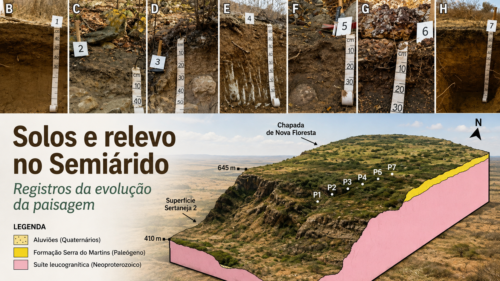
A study published in Catena shows how soils, landforms, and ferruginous crusts help reconstruct the evolution of a sedimentary plateau in Northeast Brazil and reveal a landscape that cannot be explained by the current semiarid climate alone
When we think of the Brazilian semiarid region, poorly developed soils, limited water availability, and restricted chemical weathering are among the characteristics commonly associated with the landscape. Some areas of Northeast Brazil, however, depart from this pattern. On elevated and relatively flat surfaces, deep and highly weathered soils coexist with shallow soils on steep slopes, hardened ferruginous materials along plateau margins, and zones of sediment accumulation on valley floors. More than simply reflecting soil diversity, this assemblage records different processes and timescales in landscape evolution.
This is what the article “Soil-geomorphology relationships in sedimentary plateau (semiarid region of Northeast Brazil)”, published in 2026 in the scientific journal Catena, shows. The study, authored by Danielma Ferreira da Rocha, Davi do Vale Lopes, Damião Isaac de Lira, Anderson da Silva Santos, José João Lelis Leal de Souza, and Grace Bungenstab Alves, examined how soils and landforms relate within a sedimentary plateau in the municipality of Picuí, Paraíba State.
The research was carried out in the Olho d’Água das Onças Private Natural Heritage Reserve, located within the Caatinga domain. The area is associated with the Serra do Martins Formation, a sedimentary cover found on several plateaus in inland Northeast Brazil. These surfaces are remnants of a formerly more continuous sedimentary cover that was later dissected and eroded, making them particularly valuable environments for investigating the evolution of semiarid landscapes. Rather than merely describing the soils within the reserve, the researchers sought to understand how pedogenesis and morphogenesis work together to shape the landscape.
What do soils reveal about the landscape?
Soils and landforms do not evolve independently. A soil’s position in the landscape influences water circulation, sediment removal and deposition, erosion intensity, and the conditions available for weathering. At the same time, soil properties and the materials from which they develop can either promote stability or contribute to the transformation of the landforms themselves. This interaction lies at the core of pedogeomorphology.
To investigate these relationships, the researchers combined geomorphological analysis in a Geographic Information System (GIS) environment, fieldwork conducted between 2021 and 2024, and morphological, physical, and chemical analyses of seven soil profiles. The sampling sites were selected to represent the diversity of topographic positions, geological substrates, drainage conditions, and vegetation cover present in the study area.
The analysis identified five geomorphological compartments: plateau, escarpment, flat-bottom valley, structural valley, and alluvial plain. The plateau is the most extensive unit, occupying nearly half of the mapped area. Soil distribution follows these topographic differences and reveals a gradient between sectors dominated by stability and pedogenic development and others marked by erosion, sediment transport, or accumulation.
This organization reinforces the importance of interpreting soils and landforms together in order to understand the evolution of semiarid landscapes. Individual soil profiles reveal soil properties, but their position in the landscape and their relationship with landforms help distinguish inherited features and past environmental conditions from more recent transformation processes.
At the top of the plateau, a soil that tells a different climatic story
One of the most significant findings occurs precisely on the highest and flattest surface. At the top of the plateau, the researchers identified a Latossolo Amarelo Distrófico psamítico, classified internationally as a Ferralsol (Loamic, Dystric). The profile is more than 1.20 meters deep, with well-developed Bw horizons, a relatively stable structure, and physical and chemical properties indicative of advanced weathering.
This association is noteworthy because the current semiarid environment provides limited water availability to sustain prolonged periods of intense chemical weathering under the same conditions. The low silt/clay ratio observed throughout the profile, together with its high phosphorus adsorption capacity, base leaching, and other soil properties, supports the interpretation of both an advanced stage of weathering and a long pedogenic history.
The authors relate these characteristics to pedological signatures inherited from wetter paleoclimatic conditions, later preserved by the geomorphological stability of the plateau surface. In this sense, the soil records environmental conditions that do not fully correspond to those observed today.
Studies carried out in other parts of Northeast Brazil have also identified soils and landforms inherited from wetter periods, indicating that landscapes that are currently semiarid experienced important paleoenvironmental changes. In the Olho d’água das Onças Reserve, the new study adds an essential element to this discussion: recognizing inherited soil characteristics is not enough; it is also necessary to understand how its position in the landscape favored its preservation over time.
Stable surfaces favor more developed soils
The explanation lies largely in the landform setting. The plateau top has low slope gradients and limited sediment removal. Under these conditions, pedogenesis can operate over long periods without erosion continuously removing the material. Geomorphological stability therefore favors both the development and the preservation of deep weathering mantles.
This combination of flat relief, predominantly sandy loam texture, and well-structured soil also favors infiltration and vertical water fluxes. The authors therefore interpret these surfaces as important areas for groundwater recharge in the semiarid context. The presence of a strongly leached soil under currently dry climatic conditions thus becomes less of an apparent pedological contradiction when soil, landform, water circulation, and time are analyzed together.
Along the plateau margins, nearly the opposite occurs. As slope gradients increase, material removal intensifies, and morphogenesis becomes more important relative to pedogenesis. In these areas, shallower Cambisols and Regosols predominate, some with rock or parent-material contacts at shallow depth, and are associated with stony and rocky terrain.
The contrast is particularly clear along the escarpments, where slopes may exceed 75%. These are the most geomorphologically dynamic and vulnerable sectors of the study area, exposed to erosion and mass movements. Over a relatively short distance, the landscape therefore shifts from a stable surface capable of preserving a deeply weathered soil to slopes where continuous material removal restricts soil development.
Ferruginous crusts also help sustain the relief
Another important element in this history is the presence of ferruginous materials along the plateau margins. In this sector, the researchers identified a Petric Plinthosol, developed over iron-rich materials and associated with an extremely stony surface. The profile contains a concretionary layer close to the surface, which restricts root development and creates environmental conditions quite different from those observed on the plateau top.
These hardened materials resist erosion. Rather than merely being products of weathering, ferruginous crusts can act as relief-sustaining features, helping maintain elevated topographic levels while less resistant sedimentary materials around them are progressively removed. This relationship among ferruginous materials, soils, and landscape evolution is an issue receiving increasing attention in research on tropical Plinthosols.
In the study area, degradation of these crusts also appears to contribute to relief reorganization. The authors associate this process with the development of concave forms and flat-bottom valleys. Faults and fractures may act as zones of structural weakness, favoring progressive landscape dissection. A two-way relationship therefore emerges: landscape evolution conditions the formation and preservation of ferruginous materials, and once hardened, these materials begin to influence the relief’s resistance to erosion.
These concretionary sectors also support a distinctive vegetation assemblage, including species such as macambira and cacti, adapted to high stoniness, low nutrient availability, and water deficit. This association reinforces the need to interpret soil, relief, and vegetation together and helps explain why the authors recommend particular attention to conserving these environments.
From plateau tops to valley floors: a connected landscape
If the plateau top preserves records of a long history of weathering, the lower sectors reveal the fate of some of the materials removed from higher areas. Water and sediments move downslope and converge toward the structural valley, the lowest compartment in the study area, which is probably influenced by faults, fractures, or other geological structures.
Within this system lies a small alluvial plain, where a Fluvisol formed by sediment accumulation was identified. The profile contains five horizons and distinct sedimentary discontinuities, indicating different depositional episodes. Human activity may also have modified this dynamic, since small dams previously constructed for water storage may have enhanced sediment retention.
The spatial organization of the soils therefore makes it possible to trace part of matter’s movement through the landscape. Water can transport materials removed from slopes, which later become part of the soil cover again in lower positions. What appears as erosion in one sector is expressed elsewhere as sedimentation and the formation of new soils.
This connection also highlights water’s role in differentiating the landscape. On the flat plateau surface, infiltration and vertical water fluxes favor the development and preservation of deep soils; on steeper slopes, surface runoff increases erosive potential; and on valley floors, water and sediments converge, creating favorable conditions for deposition. Other studies discussed by COLAPSO also highlight the importance of water availability in soil transformation in the semiarid region, such as research on the effects of rainfall variation on soil formation and transformation.
Soils as archives of landscape evolution
When the different geomorphological compartments are considered together, a landscape emerges that cannot be explained solely by present-day environmental conditions. On the plateau top, a deeply weathered Ferralsol preserves characteristics of a long pedogenic history and past wetter conditions. Along the margins, shallow soils record sectors where erosion limits profile development. Ferruginous crusts help preserve parts of the relief, while their degradation contributes to surface dissection. On valley floors, sediments derived from higher areas accumulate and become part of newly forming soils.
These records do not necessarily belong to the same moment in time. The coexistence of processes and inherited features of different ages makes the landscape a source of information about its own history. The soil preserved on the plateau top does not record only present-day pedogenesis, just as the relief is not merely a backdrop on which soils are distributed. Both preserve evidence of transformations accumulated over time.
This interpretation also has practical implications for conserving the Olho d’água das Onças Reserve. The study shows that the different geomorphological compartments do not have the same degree of stability and do not respond to intervention in the same way. The plateau top shows greater geomorphological stability, while the slopes of the structural valley and, especially, the escarpments are more vulnerable to erosion and mass movements. Flat-bottom valleys associated with ferruginous materials represent distinctive environments, whereas the alluvial plain, which is susceptible to flooding and sediment input, should remain subject to minimal intervention.
Understanding these differences is particularly important in a region where climate change may alter water regimes and affect both soils and landforms. The semiarid landscape is not homogeneous, and its different compartments display distinct conditions of stability and vulnerability. Understanding its history and functioning therefore provides an important basis for conservation strategies and environmental planning.
The study thus reinforces a central idea in Physical Geography: the present-day landscape contains different, overlapping timescales. Reading this history requires integrating soils, landforms, water, materials, and processes. On the sedimentary plateau of Picuí, from the Ferralsol preserved at the summit to the sediments accumulated on the valley floor, each landscape position records a different part of the trajectory of semiarid landscape transformation.
Reference
ROCHA, Danielma Ferreira da; LOPES, Davi do Vale; LIRA, Damião Isaac de; SANTOS, Anderson da Silva; SOUZA, José João Lelis Leal de; ALVES, Grace Bungenstab. Soil-geomorphology relationships in sedimentary plateau (semiarid region of Northeast Brazil). Catena, v. 273, 110410, 2026. DOI: https://doi.org/10.1016/j.catena.2026.110410.